Information about Cuatrocienegas, Mexico
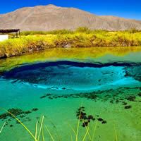 Cuatrociénegas is located in the center of the state of Coahuila from a distance of approximately 295 km of Saltillo. Biodiversity that develops on the substrate plaster Protection Area of Flora and Fauna Cuatrociénegas is unique, and makes considered as one of the most important regions gipsofilas of North America. Vegetation has an alkaline dry grassland in the floor of the basin, water and semi-aquatic habitats where the water hyacinth, native species are located; plaster dunes that lodge 6 endemic species, zone of transition and desert scrub downs, the latter with a wide variety of cacti, some protected by the goverment, and even, 4 endemic species. In the hills it is chaparral, represented by mesquite, and vegetate in the highlands mixed oak forest and pine-oak forests. The biological reserves are small ecosystems, with abundant unique flora and fauna.
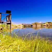 Cuatrociénegas Valley is one of the places with the highest concentration of endemic species and is within the Coahuila desert. It was decreed by the federal government as a natural area. In the pools you can perform different activities such as diving, mountain biking, landscape photography, underwater and wildlife; camping and abseiling; without forgetting the research possibilities of the life forms found there. Several groups and leaders work by the protection of this priority ecosystem, including Pronatura Noreste. The organization owns a private reserve in the valley called Pozas Azules, and conducts various projects, including the protection of native species, including stromatolites, eradication of invasive flora and fauna as well as community development initiatives and agriculture efficient use of water, combined with organic techniques.
 The pools are special Cuatrociénegas keep up to analogous 550 million years ago food chain because their microorganisms have affinities with marine species that are likely to be direct descendants of the ancient shallow seas in the area. In addition, they adapted to live in extreme conditions, such as the almost total lack of phosphorus in the water and the high incidence of solar radiation. NASA considers Cuatrociénegas one of the few ecosystems model for understanding the evolution of the early Earth and design studies about the possibility of life on other planets, like Mars. Given that wealth, land Cuatrociénegas equivalent to what the Galapagos Islands, reveals the investigator Luis E. Eguiarte, as both places are a laboratory for the evolution of species. However, in 2000 began to draw water from a nearby area Cuatrociénegas, Valle del Cava, and neighboring areas, like Ocampo-Calaveras, among others, to seed alfalfa destined to the cattle ranch and its original vegetation was removed to level land and cultivate fodder.
 It is an arid basin mountain rich in gypsum, with numerous springs whose water can be warm or cold and form small pools or great and deep lagoons, isolated or connected. For space and evolutionary complexity of the organisms that exist there, Cuatrociénegas is globally considered a priority wetlands for conservation. In 1994 the Department of Protection of Flora and Fauna declared 84,347 hectares as protected area. There are specimens there for hundreds of years were believed extinct, until some American scientists began years ago to "rediscover" thereafter by real expeditions Cuatrociénegas Valley, with months, during which remained submerged in blue pools, observing and recording details and customs of the coming and going of species that today only exist in this valley.
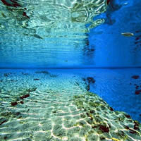 Among its attractions have spas; El Mezquite, El Entronque, made for tourist. Abundant fishing and for hunting bears and deers. And natural attractions, among them La Poza de la Becerra and Nogalito. Also, in the Sierra de la Campana is a crater called Cava. It also has restaurants and hotels in tourist class. The best time to visit this region is from Easter and during the summer, ideal for hot springs time.
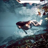 Mezquites spa; This place is located at a distance of 8 km from the county seat, taking the federal highway 30 to Torreon. Its crystalline waters have varying temperatures, ranging from 14 to 25 ° C. The services offered are rustic style, such as: palapas, tables, benches, grills, changing rooms and bathrooms. Entronque spa; especially conditioned for tourists. Abundant fishing and hunting for bear and deer. Poza Churince; Located 18 km from Cuatrociénegas by the Federal Highway 30 Cuatrociénegas-Torreon. Spa-spring of crystal clear water and varying temperatures. Poza Azul; Poza Azul in Cuatrociénegas. This pool is protected: it is not a spa. It is located 9 km from Cuatrocienegas. It has an information booth, living photographic exhibition of the flora and fauna of the reserve, toilets, palapas, grills, tables, benches, viewing platforms, self-guided trails and parking.
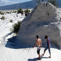
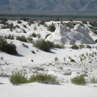
 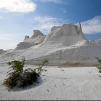 The gypsum dunes; The gypsum dunes in Cuatrociénegas. 18 km from Cuatrocienegas. It is an area of white sands (calcium sulfate). It is a unique place of its kind, considered the largest in the country, and one of the 3 best in America. It has a unique natural beauty, flora and fauna of the area; palapas, tables, benches, interpretive trails and ample parking. Ecotourism park "Illusion"; Located in the Old Miners ejido North Cuatrociénegas 46 km (11 km of road and 35 km of dirt). The services offered are lagoons, natural shades, grills, ecological toilets, tables, benches and ample space for cars. Las Playitas; This place is located 13 km dirt from the county seat. It is one of the largest bodies of water Cuatrociénegas Valley. The site is closed by the PROFEPA since 2004 for the development of tourism and recreational activities. Ejido Nuevo Atalaya (San Marcos); It is located 25 km from the county seat via Highway 30 to Torreon. Here you can find cave paintings made by indigenous groups that inhabited these places. It also has processing and extraction process cerote candelilla candelillero as there is a field where the ejidatarios of the place is mainly engaged in this activity for their livelihoods. Cerro Muerto; Located east of the town of Cuatrocienegas, this hill appears the silhouette of a body lying on the ground, and is represented in the coat of arms of the municipality. At the foot of the hill, next to the federal highway 30, there is a general Venustiano Carranza, which is visible from the point of arrival in the municipality equestrian statue of the famous revolutionary. Cerro Muerto is an additional attraction for the adventurous visitor, since it can be scaled to full height, located in what represents the "navel" of the hill, which is a small tower, where you can place banners representing the triumph of having made it to this place. Sierra de la Campana; Place which houses the crater called Cava. There are restaurants and tourist class hotels.
MexicGo © 2025
